By the outbreak of World War II, the Thames Estuary was considered a weak point in defending the main access to London and the Royal Docks. German bombers were dropping magnetic mines in the estuary.
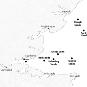
As there is no landmass to mount anti-aircraft guns, an alterative had to be found. The map below shows the positions of the seven ‘Maunsell’ forts grounded in the Thames estuary.
Navy forts
- U1 Fort Roughs, 11th February 1942
- U2 Sunk Head Fort, 1st June 1942
- U3 Tongue Sands Fort, 27th June 1942
- U4 Knock John Fort, 1st August 1942
Army forts
- U5 Nore Fort, July 1943
- U6 Red Sands Fort, August 1943
- U7 Shivering Sands Fort, October 1943
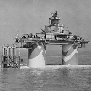
HM Fort Roughs
His Majesty’s Fort Roughs, situated on the Rough Sands sandbar, was the first of seven ‘Maunsell’ forts built to protect the Thames estuary.
Low flying German aircraft were dropping sea mines into the estuary from the early days of WWII. There is nowhere in the North Sea to mount anti-craft guns, so the forts were built to protect the estuary.
Designed by Guy Maunsell, the forts were built at Red Lion Wharf, Gravesend. Once complete, they were towed out and sunk onto sand banks.
HM Fort Roughs, was grounded on 11th February 1942 and was manned by the navy. The crew were already on board as it was towed out from Gravesend, Kent. This allowed the fort to defend itself should it come under attack. The fort was almost lost during the grounding process. It began to list badly to one side and almost overturned. Fortunately, it returned to an upright orientation before landing heavily on the seabed. The Maunsell forts had a life expectancy of 5-10 years but in 2022, Roughs Tower passed its 80th anniversary.
After WWII, the forts were placed on a ‘care and maintenance’ footing, but were soon abandoned. In 1967, Roy Bates and his family moved aboard the fort. On 2nd September they set up The Principality of Sealand. The plan was to be recognised as a sovereign state. The fort is currently owned by Prince Michael of Sealand, son of the late Roy and Joan Bates.
Sealand has its own passport, currency and flag but sadly never became a country in its own right.

Guy Anson Maunsell
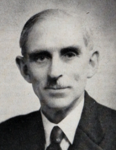
1st September 1884 – 20th June 1961
Guy Maunsell was born in Kashmir, British India. He studied Civil Engineering at the City & Guilds of London Institute. However, following his graduation in 1906, he travelled the country making watercolour paintings.
In 1907 he became an assistant to Swiss engineer Adrien Palaz, where he learned the latest techniques associated with reinforced concrete.
In WWI he was a commissioned officer in the Royal Engineers and spent a year on the western front. He then returned and was involved in building the ‘mystery towers’ in Shoreham. The only one of these surviving is known as the Nab Tower.
In WWII he became famous for his work developing the concrete forts used in the Thames and Mersey. These structures are still referred to as ‘Maunsell Forts’.
German Luftmine A
The Luftmine A (Eng. Air Mine A) was the type of weapon dropped from low flying aircraft. Two of these were dropped in the estuary on 21st November 1939, one of which was responsible for sinking HMS Gipsy.
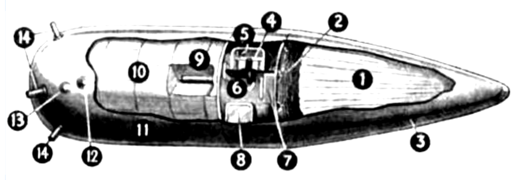
- Parachute
- Parachute ropes
- Parachute case
- Magnetic needle
- Contact
- Counter weight
- Relay
- Battery
- Detonator
- Explosive
- Metal case
- Impact detonator
- Hydrostatic valve
- Horns (to prevent rolling in tide)
Back Continue